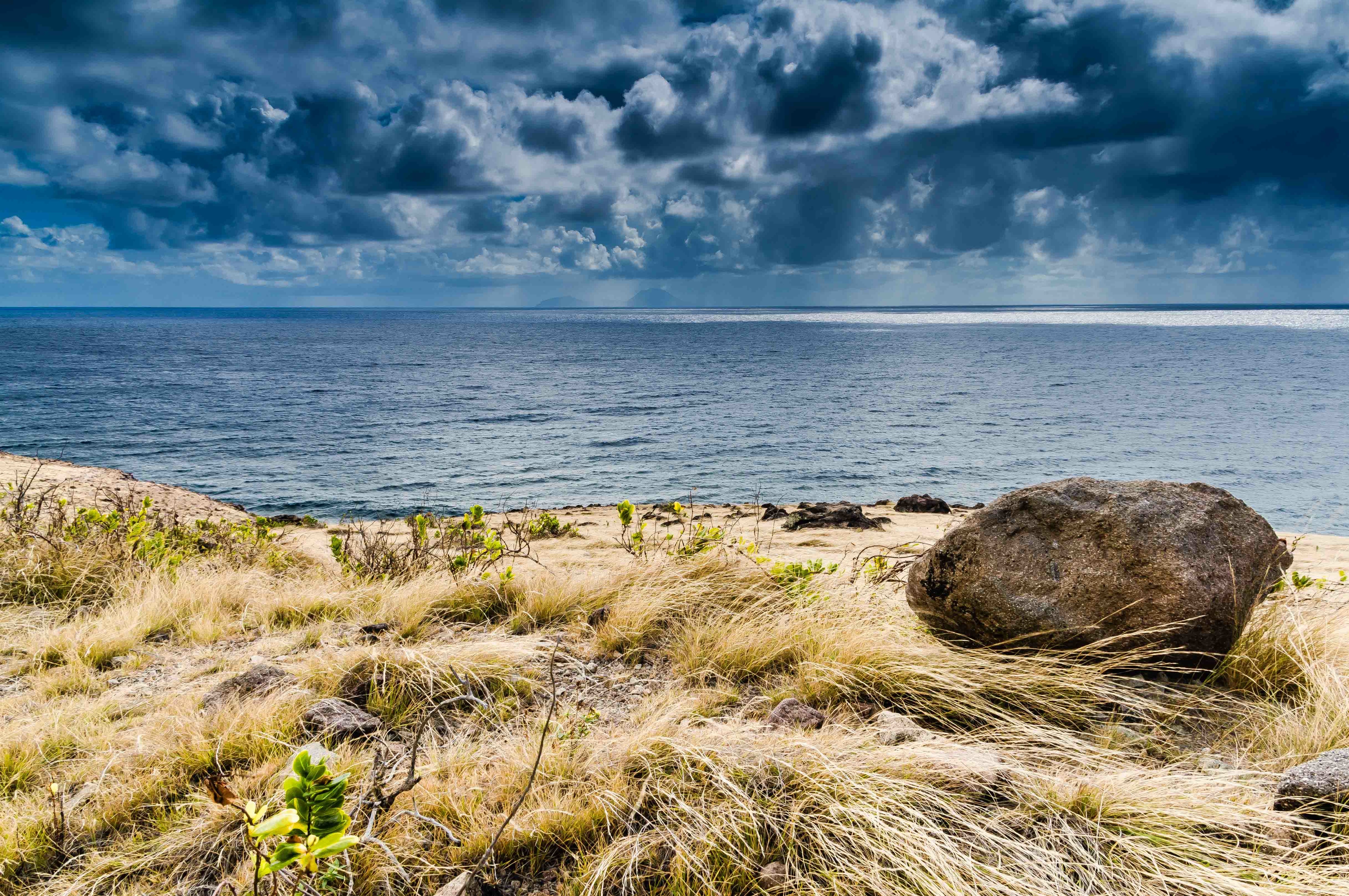
South Coast From Paris Hill, Saba, Dutch Caribbean
Hilltop Pastorale
I talked to Chef Michael from Brigadoon, and indicated I’d like to take another crack at climbing the monolithic whale tail on Paris Hill. Hoping he can come with me, as he’s done it several times before, and it’ll help me to see how before I tackle it. We’ll see. In the meantime, here’s a sample of the gorgeous south coast views of Saba from Paris Hill. I’d like to especially thank the foreground yucca for acting like a mini-sunrise accent to the picture when only minutes before, that seemingly innocent sunny plant’s serrated edges had ripped a variety of tiny holes in my calves when I came over the ridge to the summit. Flora dualism or have I finally reached a point where I’m anthropomorphizing Saba’s durable vegetation as a lame cover for poor hiking skills? I’ll leave that opinion to you, dear readers. Cheers and have a great day!
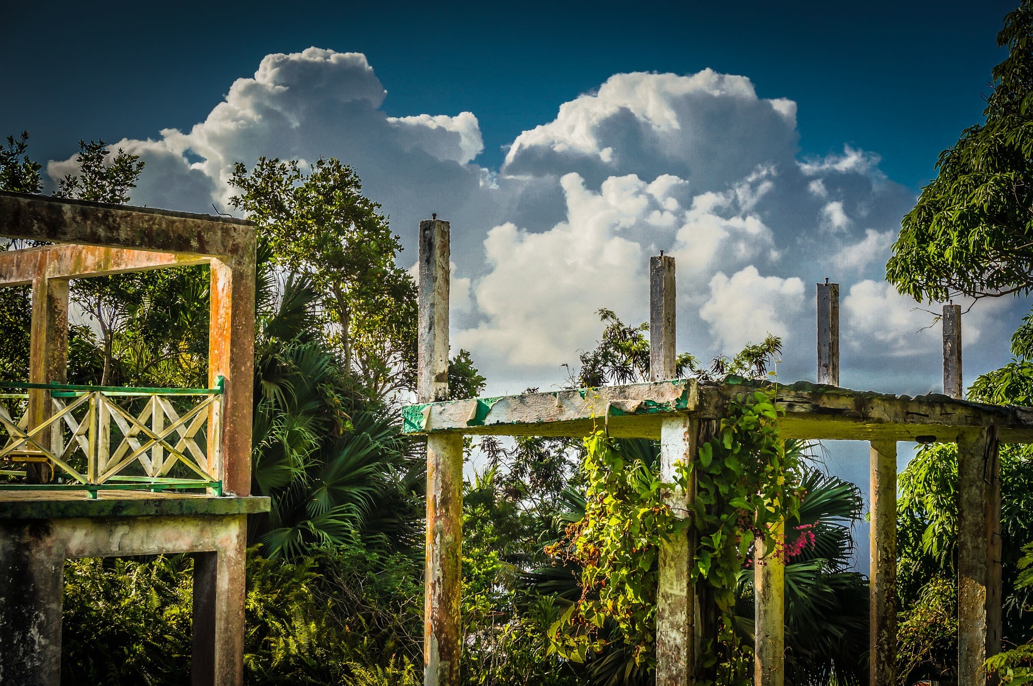
Clouds Billow Over The Structural Remains of Captain’s Quarters Hotel, Saba, Dutch Caribbean
Views like this, though they hold sad memories for some, inspire me to write, because the earth and sky still create magical art together every day here on Saba. The novel continues to move forward, no slower or faster than my muse will allow, and I’m ok with that. Que sera sera, amigos y amigas!
I saw my brother off on the plane this afternoon after an intense twelve days, rambled up Hell’s Gate in record time following beautiful girls who just happened to be walking up as well, realized I forgot today’s blogpost, attempted to meet a French scientist in The Bottom, chatted with mi amigo Michael Irish, and at long last, here I be with you, listening to the wind blow fiercely here in St John’s. C’est la vie here on Saba, friends. Small wonder I’m sharing these floaty, cloudscapes over the mountain, eh? Just that kinda mood.
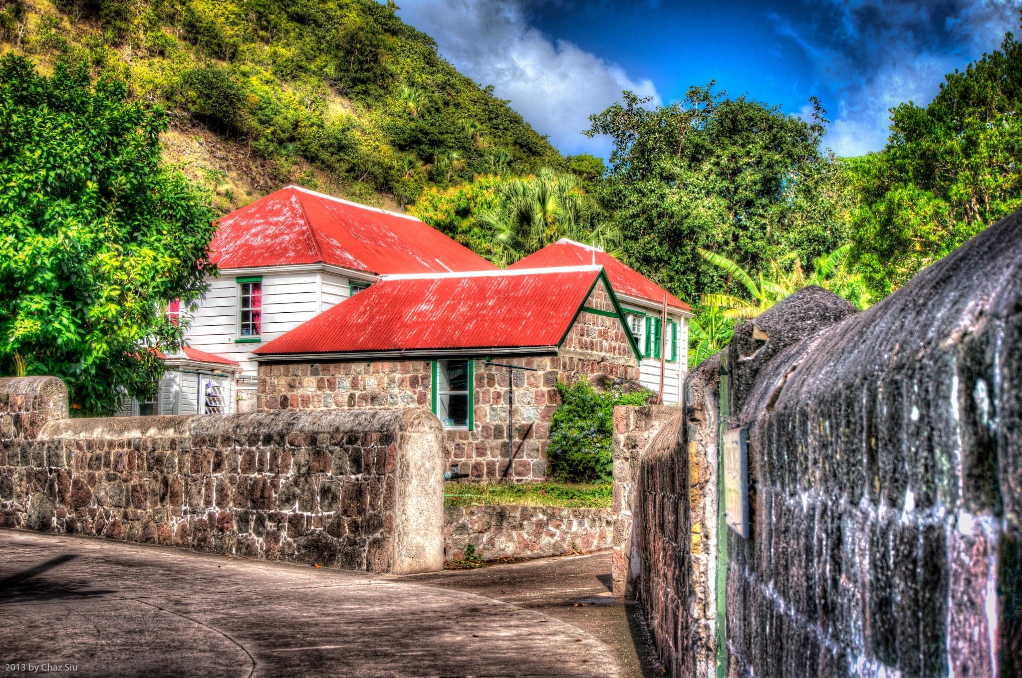
Saban villages are lovely settings for these red tin roof cottages and houses, their wash white painted shingles, their green gabled shutters. You walk the friendly Road and people young and old greet you with a variety of waves and acknowledgements; I think brother Michael has catalogued ten or more different waves in his visit here. Those of you who havent been, put Saba on up your bucket list and come here one day to witness in person what I’ve tried to convey in this blog, this charming rock and its rugged shores and guts and mountains, its hardworking people.
When two photographers walk together, particularly brothers, often as not, they happen upon scenes or settings where they both see the image to be captured; so it is with today’s picture. We were on our way through The Bottom to hike The Ladder when we turned the corner near the Thomas Dinzey cemetery and came upon this juxtaposition of Saban houses against Paris Hill greenery, a clouded sky above. We both saw it at almost the same time…I snapped a few pics, he snapped a few pics, here’s my favorite of mine. Hope you enjoy it!
My brother has arrived on Saba isle for a brief visit and brought a rescue camera so I can continue to bring you my shots of this lovely Caribbean paradise. Three cheers for him!
Today, some stunning cumulonimbus clouds stack like cotton candy above Peak Hill In Windwardside, with a view to the top of the Wash Gut that I climbed up with the scientist last week
South Coast Cloudscape, Statia, and St. Kitts Views, Saba, Dutch Caribbean
Giles Quarter, Geomorphology, and the Gut Adventure
Pardon my alliterative heading there…two days ago I agreed to guide a French geomorphologist down the Giles Quarter coastline trail and up the Gut to Windwardside. Gut is what the Sabans call the steep, winding ravines that slash downwards all over the volcanic island; many are off trail canopies of thick and ropy shrub and foliage that winds itself around anything on your person and cuts and scratches any exposed skin. But hey…an adventure, right?
We picked up orange hard hats at the Conservation Bureau down in Fort Bay- natural and goat induced rockfall is common on Giles Quarter–then set off down the coastline. Cristian is a gregarious living archetype of the absent minded professor; in the case of our hike, the shiny objects of his interest were various examples of geomorphology/vulcanology on Saba: conglomerate, alluvial stream beds, plants thriving in microclimates in the various Saban ecosystems. Rocks, dirt, plants, and terrain…wahoo.
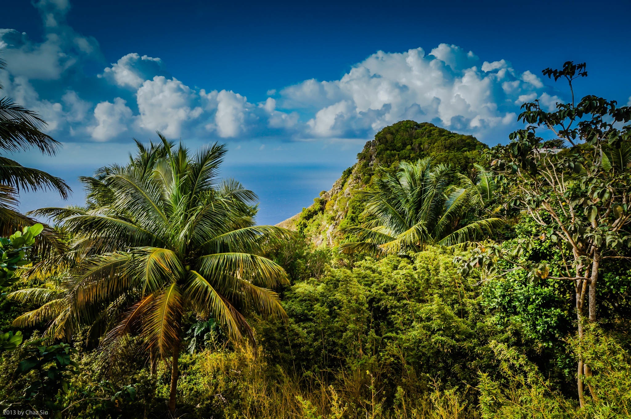
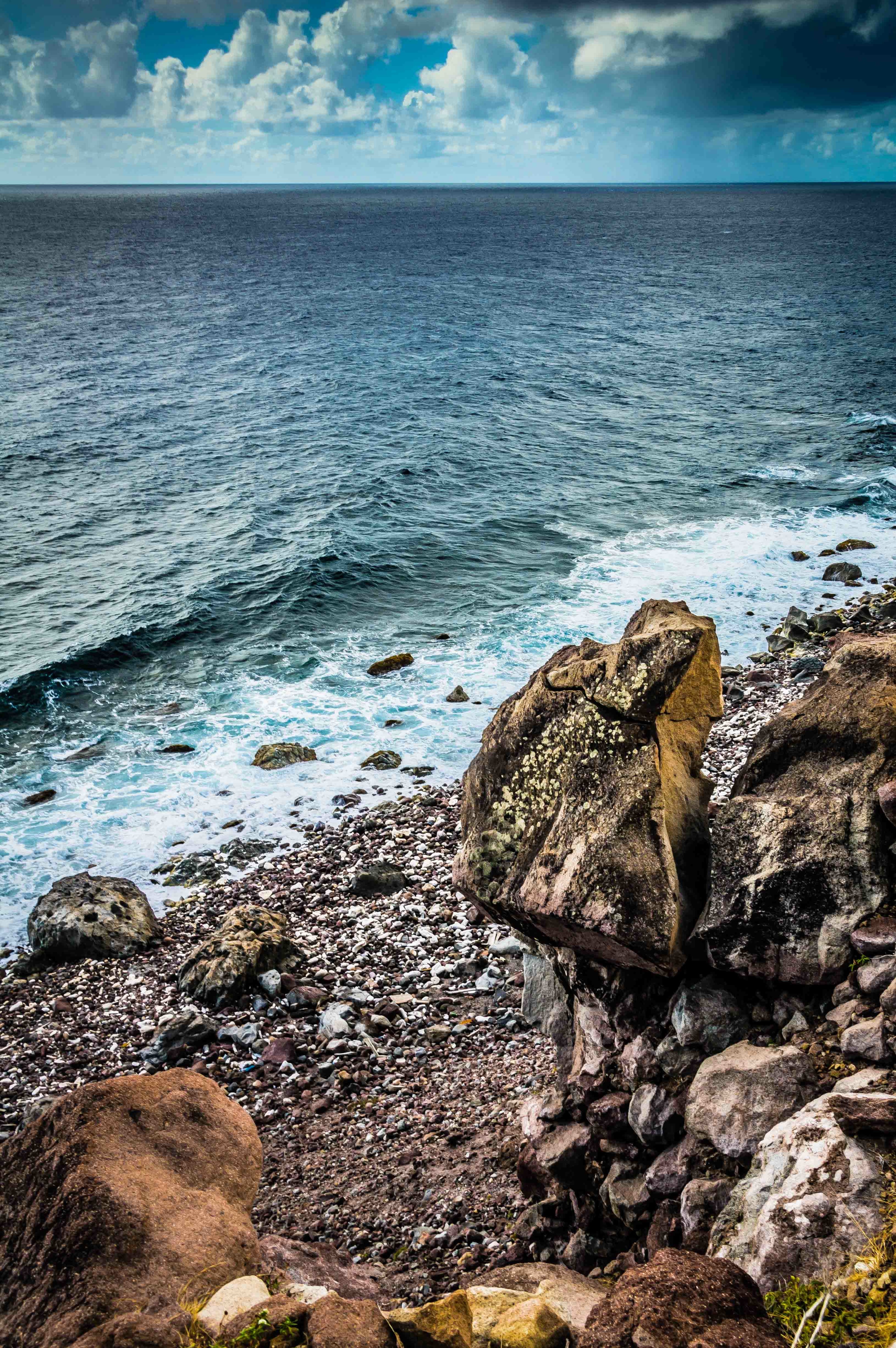
Up close and personal on the Saba south coastline, we could see fields of long yellow grass laid flat by gusty breezes. In the picture, just beyond the long grass, there’s an abrupt 10-20 foot cliff drop off to the rocky Saba shore (shown with the balancing rock photo), with big swells coming in vis a vis the northwest tradewinds.
Balancing Rock, Saba South Coastline
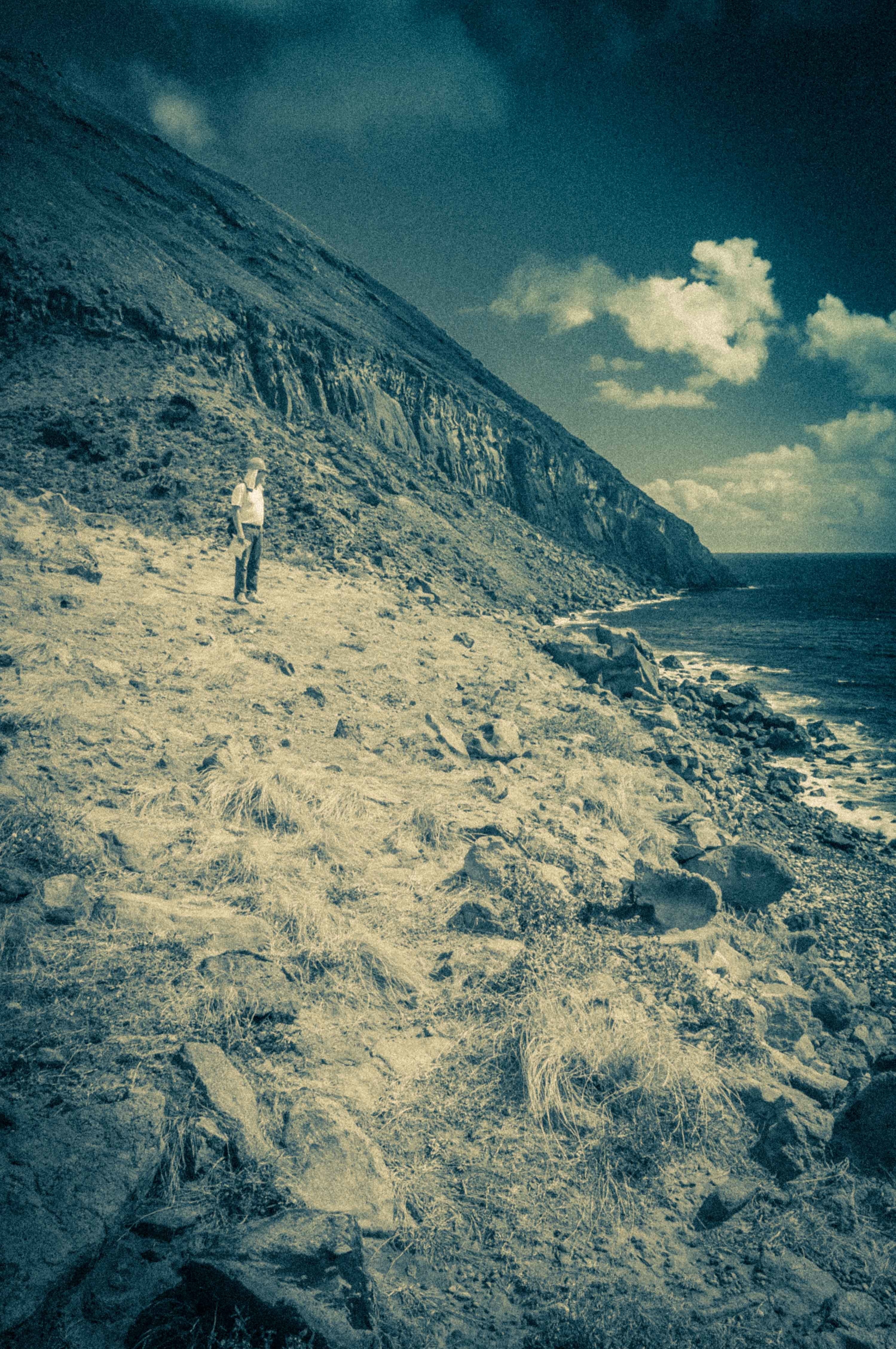
I tried to persuade Cristian to take one of the ridges for our ascent up to The Road, which are relatively scrub free, straightforward ascents, but he really wanted to wade into the Gut that comes right into Windwardside (~1400 feet) to get his “cross section” of the island. Looking up we knew it was going to be a scrub fight, and, when we got up towards the top of the ravine, some fairly vertical cliff and rock scrambling.
Cristian At The Base of the Windwardside Gut
The story ends thusly: it took us 2 hrs to get to the base of the scrub in the Gut, and an additional 2-3 hrs to climb out to the road via separate paths.
At some point, fairly well cut up from scrub, Cristian took off up the left side of the Gut walls while I reasoned it would be safer to brute force my way through the canopy up the low slope of the Gut stream bed. When I hit a impassable rock and scrub wall, I started up the fairly vertical walls, at times swinging from embedded tree root systems across rock walls with very little foothold and pulling myself up past loose rock. A little Tarzanesque, ‘cept I ain’t no king of the jungle. I emerged out at the Captain’s Quarters ruins per plan, a bit tired and having gone through 4.5 liters of water and still feeling like I’d lost weight. Cristian walked up to the Trail Shop about 30 minutes later. He had major abrasions all over his forearms, his neck red from 5 hrs in the sun despite sunblock. I was just dirty, sweaty, and my arms looked like the result of a minor cat fight. We had a beer at Saba Snack, recounting our adventure while he expressed some regret I hadn’t followed him to take pictures of the “marvelous” geomorphology on his route and apologized for getting separated.
I’m all for a little off trail from time to time, but coulda used a machete and some gloves on this one. Easy to see why visitors on Saba could underestimate the effort to work through jungle and scrub when looking at it from above. Think I’ll save my future Saba climbing efforts to the more tried and true trails and ridges. All the effort but less poky scratchy plants and rock climbing sans rope 🙂
Golden Light on Christmas Morning in Saba, Dutch Caribbean 2012
It’s Christmas, 2012 – wishing you the happiest of holidays to you and yours wherever you are. Lots of interesting pictures and mini-stories to share with you on this lovely day in Saba, Dutch Caribbean.
If you have the bandwidth, be sure and click on the smaller pictures in this post to blow them up to their full resolution selves. I’m uploading them full sized so folks can see all the great detail on Saba.
Windwardside
Windwardside At The Foothills of Mt Scenery
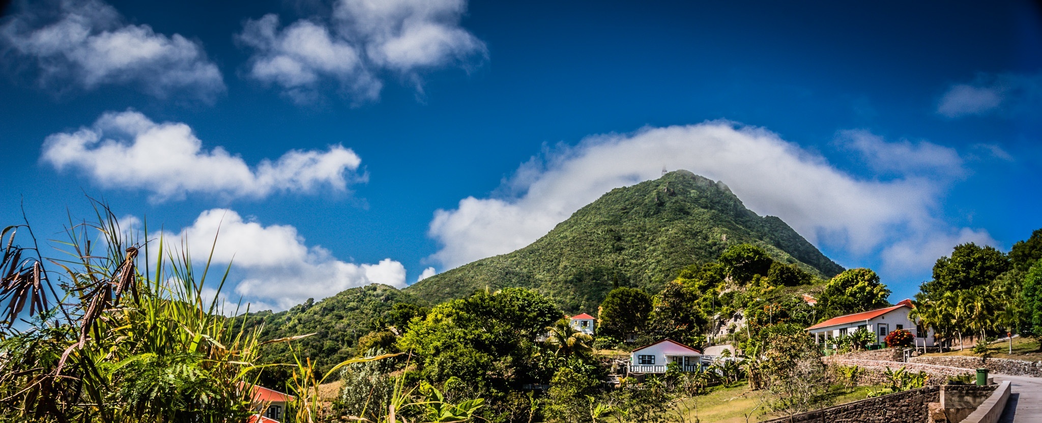
On Christmas Eve, I did my 22 minute walk on The Road to Windwardside, the largest village on Saba, nestled roughly around 1400 feet elevation with views to the northeast to the islands of St. Maarten, and St. Barts and to the southeast Statia, St Kitts and Nevis, and on clear days, Monsterrat. More importantly, Windwardside is nestled in the foothills and valley below Mt Scenery, which presides above it like an intimidating parent. Generally, Mt Scenery has its top clouded by the fog bank for which its known (and I’ve written about in prior posts), but this is the dry season, so the communication tower is clearly visible 1400 feet above the village. If you look at prior Windwardside post pics from Mt Scenery, this is a picture of Windwardside from the opposite side, from a steep road up to The Level and Booby Hill. I had Christmas Eve dinner with a friendly Canadian gal named Susan at Shearwater Resort up on Booby Hill, and I climbed this road twice in doing so. The breezes are intermittent and cooling, with 15-20mph gusts that cool the sweat off my overheated core after dragging my sorry butt up these steep hills. Since I wanted to dress in a little nicer shirt for dinner, I made the 30 minute jaunt from my St Johns cottage (about a 500 ft elevation gain) in my quick dry shirt, cooled down for a half hour outside the resort, changed shirts and I was good to go. I’m a San Francisco food lover (“foodie”) and I have to say, Saba has a pretty impressive ratio of fine chefs on the island for a population of 1400 or so, all the more creative because lots of the food has to get shipped in from the other islands: St. Maarten or farther. Christmas Eve dinner was beef tenderloin with a fine cheese wafer with both a cream sauce and a demiglace. Not bad.
Colors and Cottages
Saba History MuseumAngelican Church Below Mt Scenery
All Christmas Eve day, I wandered around Windwardside, unsure of the protocol for taking pictures and not wanting to step all over private property, although on Saba the “private” concept is somewhat relative. I’ve been particularly cautious around cemeteries, though I’m very tempted, as the crypts are semi-above ground, and generally sealed in the fiery gray volcanic rock endemic to the island. I decided to snap a couple pictures of the Saba History Museum (which I’ve not been to yet) and an Anglican Church located at the entrance to the village. The reds, whites, and greens just pop on this island. Ocean, village, or mountain views, pictures simply can’t capture the dramatic–sometimes overwhelming–beautiful views on the island. I don’t want to get used to it. I choose to be immersed, as this is the kind of place where nature is a spirituality unto itself. Can’t help but feel, calm, relaxed and unhurried wherever I wander. Talk to any locals or the expats who gave it all up to come here and live, and it’s the personification of jeune c’est quoi; you can’t put your finger on how to explain Saba, you simply have to be here, as the cliche goes. Below is a long lensed shot of Saba from The Road to The Level that provides a cool perspective of the bright red roofs, whitewashed sides, and gabled shutters that are indicative of the Saban architecture. Not having been to Holland, I’ve not idea whether this is what Amsterdam or rural Holland must look like, but it’s consistent and beautiful here. That’s the Catholic Church in Windwardside below. As the son of an almost-nun, I think I sort of remember what happens in there, but I happen to be a recovering Catholic myself, so my thoughts are the usual garble of remembered dogma, community, and cool wafers and wine for kids on Sunday.
Here There Be Hurricane Ghosts
Captains Quarters Restaurant 15 Yrs After Hurricane GeorgesCaptains Quarters Restaurant Looks Out On The SeaApartments Destroyed By Hurricane Georges
The last major hurricane to smack Saba head on with real and serious damage was 1998’s Hurricane Georges, a nasty whippersnapper that tapped 6 islands and managed $6 billion in damage. I remembering visiting Saba in 1995 by way of s/v Polynesia, one of the fleet of Windjammer sailing ships, and I vividly recall getting chased by Hurricane Luis down in these waters, a massive green blotch that consumed most of the ship’s macro scale radar. By comparison to, say, nearby St. Kitts (which you can see in many ocean pics from this blog’s prior posts), Saba was relatively spared from the wrath of Georges. Though there are sources that say Saba is impacted by more hurricanes than any other island in the world, as far as I know, the island has suffered no direct hurricane deaths. But there was a one fabled structural fatality: Captain’s Quarters, which had hosted Queen Beatrix of the Netherlands in its heyday. Here’s a couple pictures of the bar/restaurant hotel, a stark black and white of the place, which appears untouched in 15 years, and the view from the damaged structure out to the sea, perched on the cliff. The hotel itself was cleared in 2007. The owner wasn’t insured (no small matter on Saba, I’d guess) to replace the buildings. I’m told by islanders that a wealthy lady has purchased the property, and plans to renovate it soon. Wandering up the steep street a little further and I came across the bones of another victim. Not sure if this is part of the CQ complex or not, but again, the undisturbed ruins, complete with overgrown foliage, makes for really fascinating visuals, even if it is relatively recent history. Half the reason I take these particular pictures is so I have the details in front of me to describe what I’m seeing to the readers of this murder mystery I’m writing.
The Road Redux
I’ll close this long Christmas post out with more talk of things unchanged; My Christmas Eve walk from Windwardside back to St. Johns on the rollercoaster architectural achievement that is the Road, with its stone masonry of volcanic rock that looks like it could withstand hundreds of years to come. It’s a pleasure to walk along this undulating beast, gazing out on the vast wide Caribbean from on high, down the plunging ravines, watching the multitude of goats of all colors sprint up and down its slopes, sun dropping low in the sky as the night closed out, illuminating the best cloudscapes I’ve seen yet. I hope you agree.
Thanks again for the comments – always appreciated and welcome. If you happen to be fact or spell checking my blog and catch a mistake, please let me know and I’ll get it corrected immediately.
Happy Holidays!
Chaz
Cloudscapes On The Road to St JohnsThe Road Below The Old GEBE Station