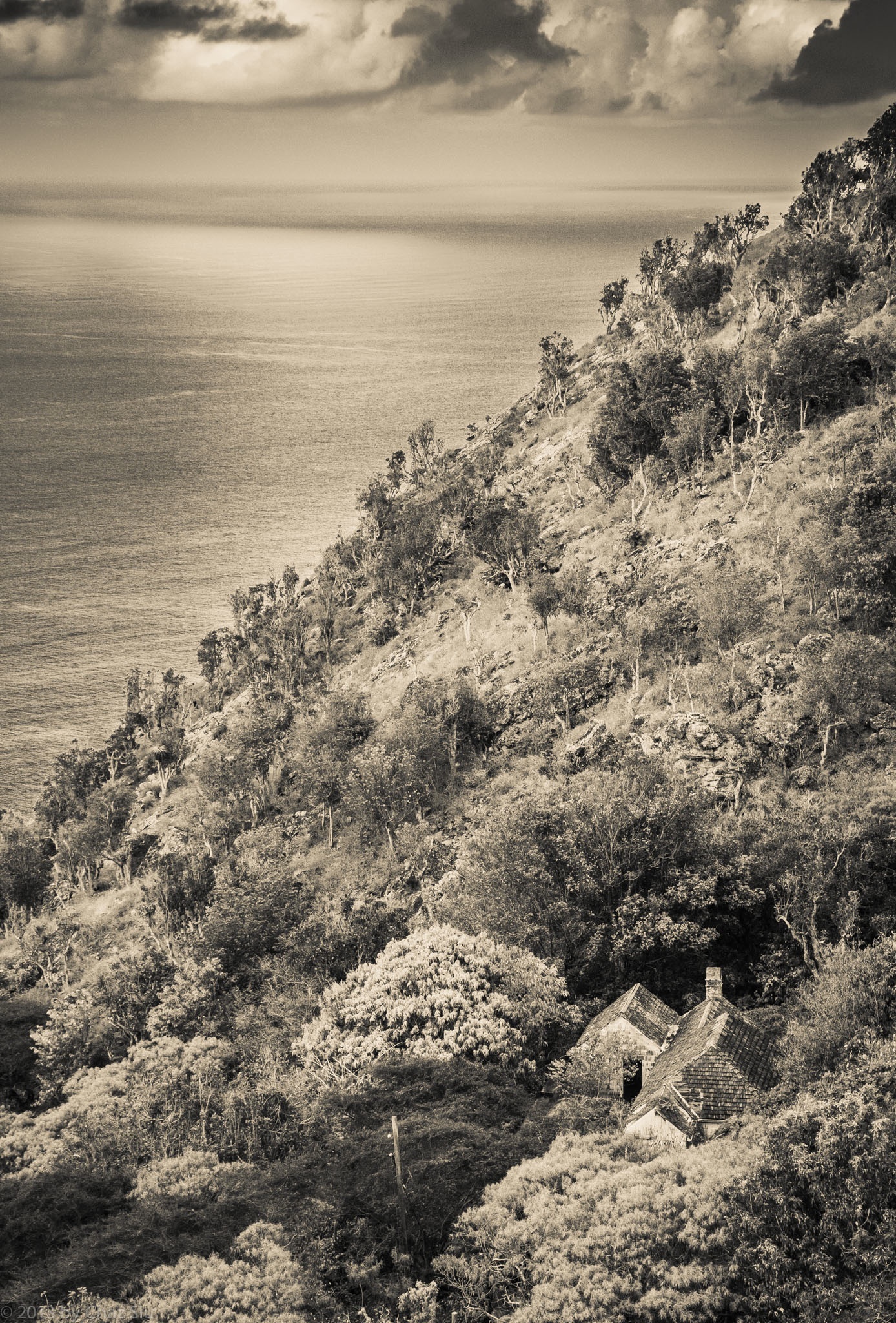
St. John’s House At The Base Of Thais Hill, Saba, Dutch Caribbean
The last few days have been me getting up earlier and earlier to try and beat the dreaded heat with no wind and do a bunch of ridge hikes up from the Giles Quarter coastline midway between the St. John’s Flat and the Wash Gut up to Windwardside. Saba’s terrain is so rugged and steep, it amplifies the actual distance you’re hiking, which is usually between 3-5 kilometers, but can feel like a lot more. Regardless, even at 7:00am, the heat is beating down mercilessly as I haul my big ol’ self up this rock.
In any case, repeated trips down to Fort Bay to start these coastline-ridge excursions had me passing this little house nestled in the cleft between St John’s Flat and Thais Hill. It’s an old style house, with rare brown wooden shingles rather than the traditional red corrugated tin,though you can’t tell from my processing it in black and white. My guess is that it’s well protected from the ravages of hurricanes and tropical storms as well, but I don’t know yet who, if anyone, lives in this nostalgic little house, but it sure looks cool from above, n’est cd pas?
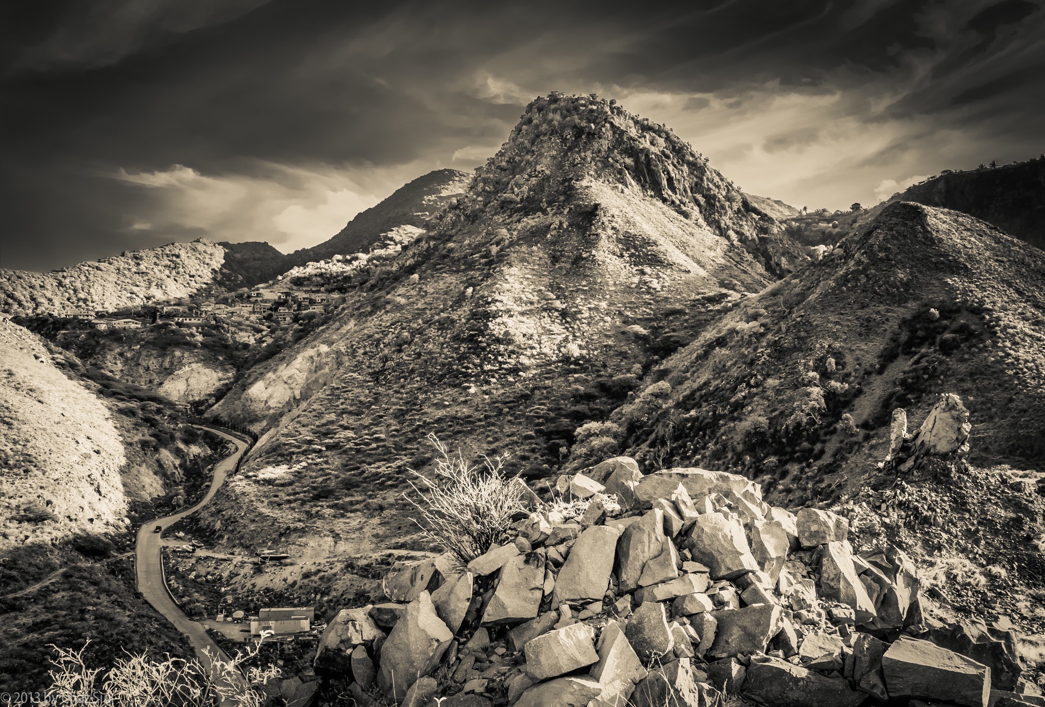
Road To Fort Bay Winds Down Below Thais Hill, Saba, Dutch Caribbean
“The greatest gift of life on the mountain is time. Time to think or not think, read or not read, scribble or not scribble — to sleep and cook and walk in the woods, to sit and stare at the shapes of the hills. I produce nothing but words; I consumer nothing but food, a little propane, a little firewood. By being utterly useless in the calculations of the culture at large I become useful, at last, to myself.”
― Philip Connors
Though this quote is in reference to hiking and camping on the mountain, I still think it sums up the essence of my coming here, particularly that last bit. I love the city I live in, but equally do I love this rugged rock, the peace and tranquility of its folks and its setting, above and below the water. People ask me if I miss the city, and my general answer is no, I’m focused on wringing out every bit of distraction free relaxation until the day I leave, and on the plane, I’ll get excited about where I’m going; I’m so much better at living in the moment at this stage in life, no apologies or regrets.
When you walk down the steep and sidewinder curves of The Road down to Fort Bay, you can take a mild detour to climb onto the hill above the harbor, across from Bunker Hill. Rather than looking towards the sea, where the Dutch Navy frigate was bringing in 60,000 liters of relief water to the hospital, the government building, and the old folks home due to our current drought, I looked back up at Thais Hill, which looms over the road, and up to the edge of the St John’s Flat, close to where I live. Never a shortage of new angles, and this one really shows off the rugged nature of this auld rock, forever subject to the wear and tear of weather, the thin wisps of stratus clouds high aloft and skimming the atmosphere. Not bad, Saba, not bad at all.
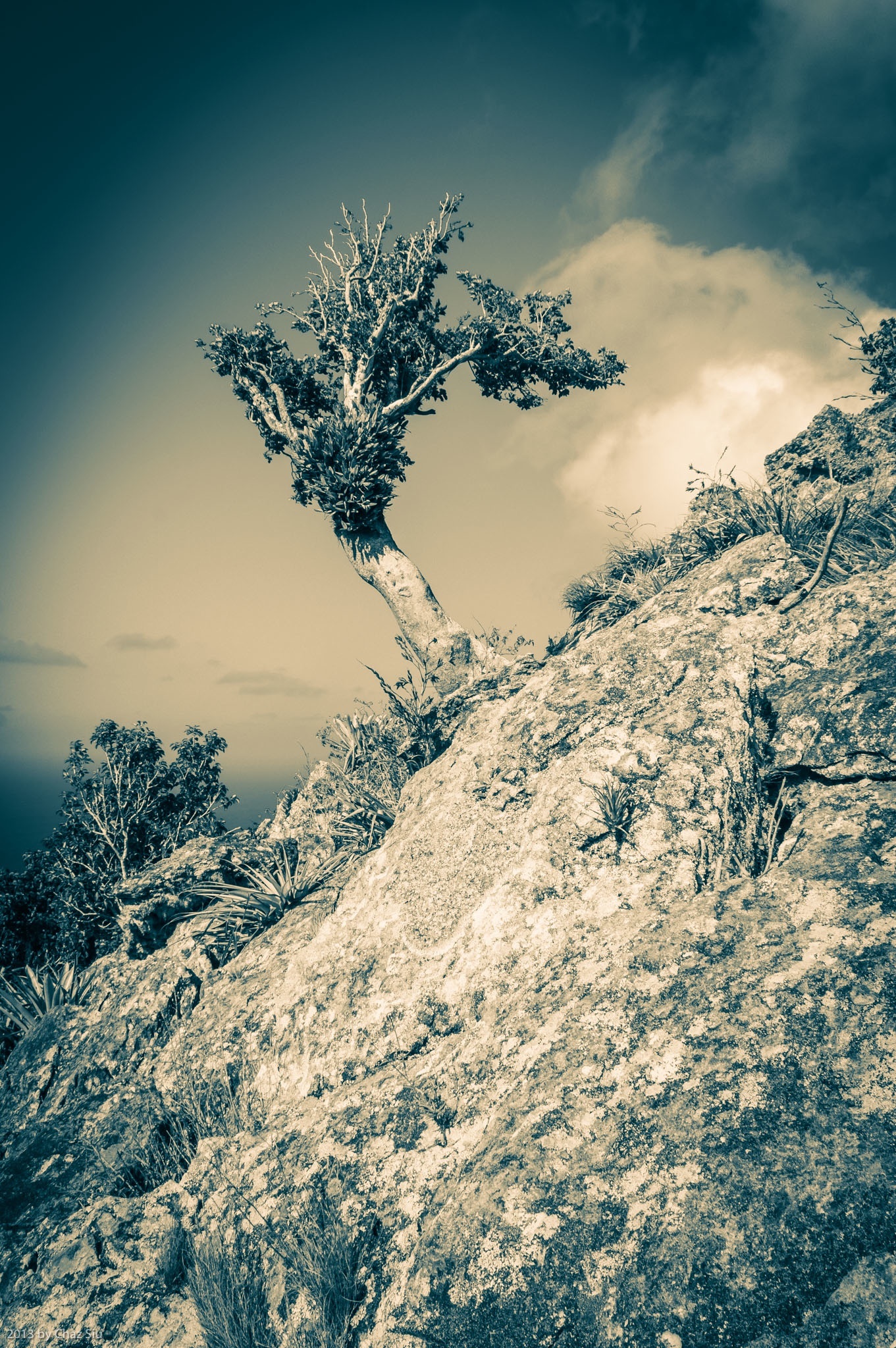
You may recall an earlier blogpost of the whale on Paris Hill, above the village of The Bottom. Today’s hike was to summit the hill and get up close and personal to said whale, but it proved to be anything but trivial. Indeed the hike up to the base of the whale was literally 12 minutes, but then it was a sheer, steep boulder scramble up sawtooth yucca and other cactus, that ended up taking an hour and a half. This rock climbing was easily comparable to the off trail route to Hot Springs (a no access trail) that Chef Michael from Brigadoon took me on a few weeks ago. Lots of route calculating as far as where my feet were going and where I was going to get handholds on the volcanic rock. In the end, it was worth it, as I snapped lots of pictures from the dramatic views up there. I managed to make it to the tail, called Tent Rock, but I just didn’t have the huevos to haul my fat butt up that sheer red face with 1400 foot dropoffs to the cliffs and bay below. Maybe another day. The yucca and cacti took a bloody chunk out of my legs on the way down; I’ll wear long pants next time I’m up here.
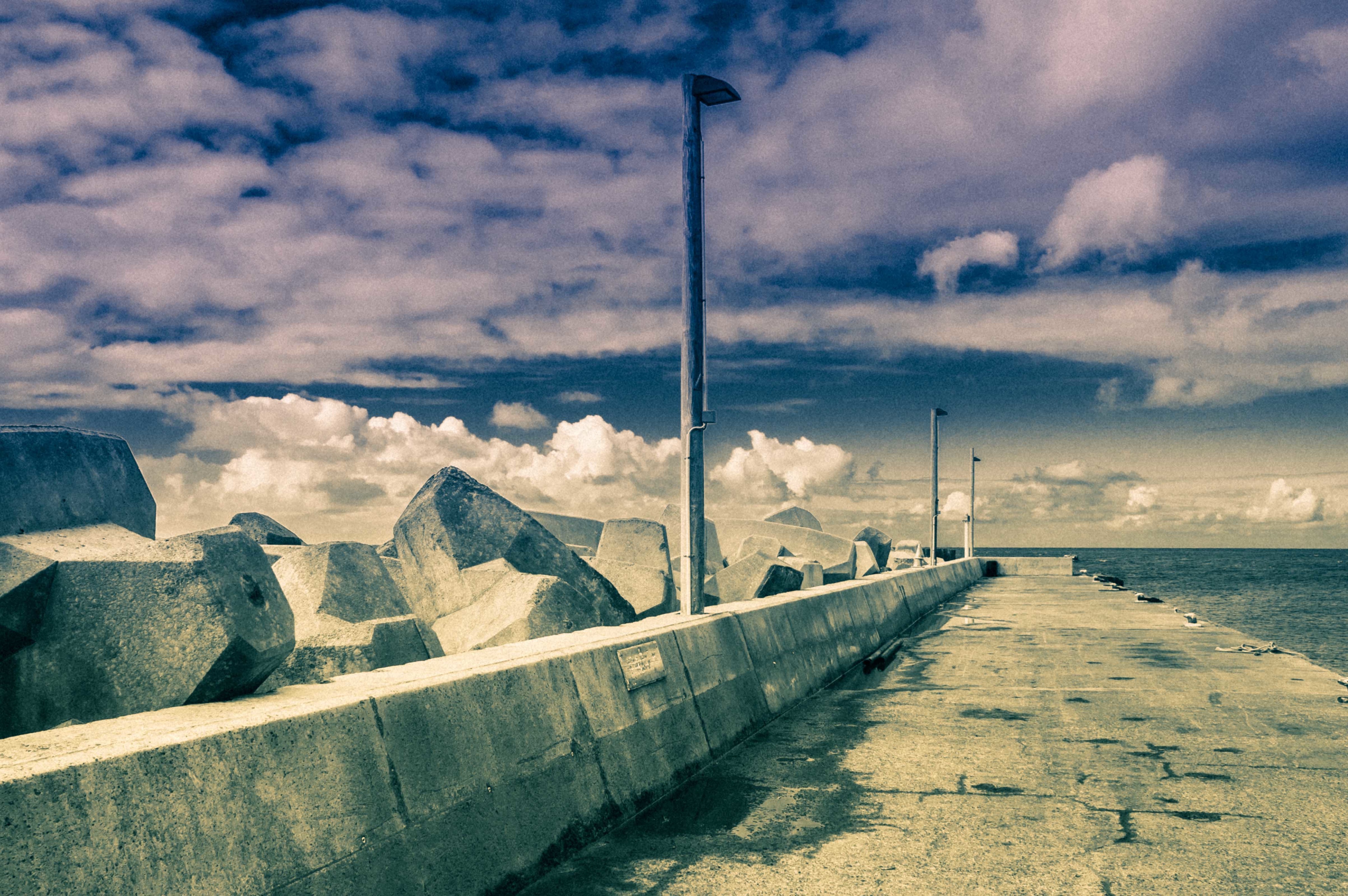
It’s easy on Saba to forget that the two primary transportation hubs to the island: the pier and the airport, are relatively modern conveniences. Though The Road was built in 1937-1953 the airport came along in 1963, and the Fort Bay pier was only completed in 1972, and it has been rebuilt and repaired from hurricanes several times since, due to its exposure. The current Fort Bay pier is huge concrete chunks as breakers, but I thought this picture kinda captures the vintage feel of it, complete with Saba’s dramatic cloudscapes. Enjoy!
Golden Light on Christmas Morning in Saba, Dutch Caribbean 2012
It’s Christmas, 2012 – wishing you the happiest of holidays to you and yours wherever you are. Lots of interesting pictures and mini-stories to share with you on this lovely day in Saba, Dutch Caribbean.
If you have the bandwidth, be sure and click on the smaller pictures in this post to blow them up to their full resolution selves. I’m uploading them full sized so folks can see all the great detail on Saba.
Windwardside
Windwardside At The Foothills of Mt Scenery
On Christmas Eve, I did my 22 minute walk on The Road to Windwardside, the largest village on Saba, nestled roughly around 1400 feet elevation with views to the northeast to the islands of St. Maarten, and St. Barts and to the southeast Statia, St Kitts and Nevis, and on clear days, Monsterrat. More importantly, Windwardside is nestled in the foothills and valley below Mt Scenery, which presides above it like an intimidating parent. Generally, Mt Scenery has its top clouded by the fog bank for which its known (and I’ve written about in prior posts), but this is the dry season, so the communication tower is clearly visible 1400 feet above the village. If you look at prior Windwardside post pics from Mt Scenery, this is a picture of Windwardside from the opposite side, from a steep road up to The Level and Booby Hill. I had Christmas Eve dinner with a friendly Canadian gal named Susan at Shearwater Resort up on Booby Hill, and I climbed this road twice in doing so. The breezes are intermittent and cooling, with 15-20mph gusts that cool the sweat off my overheated core after dragging my sorry butt up these steep hills. Since I wanted to dress in a little nicer shirt for dinner, I made the 30 minute jaunt from my St Johns cottage (about a 500 ft elevation gain) in my quick dry shirt, cooled down for a half hour outside the resort, changed shirts and I was good to go. I’m a San Francisco food lover (“foodie”) and I have to say, Saba has a pretty impressive ratio of fine chefs on the island for a population of 1400 or so, all the more creative because lots of the food has to get shipped in from the other islands: St. Maarten or farther. Christmas Eve dinner was beef tenderloin with a fine cheese wafer with both a cream sauce and a demiglace. Not bad.
Colors and Cottages
Saba History MuseumAngelican Church Below Mt Scenery
All Christmas Eve day, I wandered around Windwardside, unsure of the protocol for taking pictures and not wanting to step all over private property, although on Saba the “private” concept is somewhat relative. I’ve been particularly cautious around cemeteries, though I’m very tempted, as the crypts are semi-above ground, and generally sealed in the fiery gray volcanic rock endemic to the island. I decided to snap a couple pictures of the Saba History Museum (which I’ve not been to yet) and an Anglican Church located at the entrance to the village. The reds, whites, and greens just pop on this island. Ocean, village, or mountain views, pictures simply can’t capture the dramatic–sometimes overwhelming–beautiful views on the island. I don’t want to get used to it. I choose to be immersed, as this is the kind of place where nature is a spirituality unto itself. Can’t help but feel, calm, relaxed and unhurried wherever I wander. Talk to any locals or the expats who gave it all up to come here and live, and it’s the personification of jeune c’est quoi; you can’t put your finger on how to explain Saba, you simply have to be here, as the cliche goes. Below is a long lensed shot of Saba from The Road to The Level that provides a cool perspective of the bright red roofs, whitewashed sides, and gabled shutters that are indicative of the Saban architecture. Not having been to Holland, I’ve not idea whether this is what Amsterdam or rural Holland must look like, but it’s consistent and beautiful here. That’s the Catholic Church in Windwardside below. As the son of an almost-nun, I think I sort of remember what happens in there, but I happen to be a recovering Catholic myself, so my thoughts are the usual garble of remembered dogma, community, and cool wafers and wine for kids on Sunday.
Here There Be Hurricane Ghosts
Captains Quarters Restaurant 15 Yrs After Hurricane GeorgesCaptains Quarters Restaurant Looks Out On The SeaApartments Destroyed By Hurricane Georges
The last major hurricane to smack Saba head on with real and serious damage was 1998’s Hurricane Georges, a nasty whippersnapper that tapped 6 islands and managed $6 billion in damage. I remembering visiting Saba in 1995 by way of s/v Polynesia, one of the fleet of Windjammer sailing ships, and I vividly recall getting chased by Hurricane Luis down in these waters, a massive green blotch that consumed most of the ship’s macro scale radar. By comparison to, say, nearby St. Kitts (which you can see in many ocean pics from this blog’s prior posts), Saba was relatively spared from the wrath of Georges. Though there are sources that say Saba is impacted by more hurricanes than any other island in the world, as far as I know, the island has suffered no direct hurricane deaths. But there was a one fabled structural fatality: Captain’s Quarters, which had hosted Queen Beatrix of the Netherlands in its heyday. Here’s a couple pictures of the bar/restaurant hotel, a stark black and white of the place, which appears untouched in 15 years, and the view from the damaged structure out to the sea, perched on the cliff. The hotel itself was cleared in 2007. The owner wasn’t insured (no small matter on Saba, I’d guess) to replace the buildings. I’m told by islanders that a wealthy lady has purchased the property, and plans to renovate it soon. Wandering up the steep street a little further and I came across the bones of another victim. Not sure if this is part of the CQ complex or not, but again, the undisturbed ruins, complete with overgrown foliage, makes for really fascinating visuals, even if it is relatively recent history. Half the reason I take these particular pictures is so I have the details in front of me to describe what I’m seeing to the readers of this murder mystery I’m writing.
The Road Redux
I’ll close this long Christmas post out with more talk of things unchanged; My Christmas Eve walk from Windwardside back to St. Johns on the rollercoaster architectural achievement that is the Road, with its stone masonry of volcanic rock that looks like it could withstand hundreds of years to come. It’s a pleasure to walk along this undulating beast, gazing out on the vast wide Caribbean from on high, down the plunging ravines, watching the multitude of goats of all colors sprint up and down its slopes, sun dropping low in the sky as the night closed out, illuminating the best cloudscapes I’ve seen yet. I hope you agree.
Thanks again for the comments – always appreciated and welcome. If you happen to be fact or spell checking my blog and catch a mistake, please let me know and I’ll get it corrected immediately.
Happy Holidays!
Chaz
Cloudscapes On The Road to St JohnsThe Road Below The Old GEBE Station